THE WESTERN PILOT,
BY SAMUEL CUMINGS,
1829
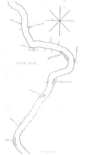
MAP NO. 16.—OHIO RIVER,
About two miles below Rockport is a bar on the right: channel pretty near to the left shore, until you are nearly up with Puppy creek, on the left, then keep well over to the right shore above Yellow Bank islands, and when within half a mile of the first, (a small island pretty close to the right shore) steer pretty short over to the left shore: opposite the head of the second, or large island, is a sunken ledge of rocks, about fifty yards from the left shore; incline a little to the right past them, and then toward the left shore again
OWENSBURGH, left side, 8-742
Is a pleasant little town in Kentucky, at the Yellow Banks, opposite the foot of the island. About a mile and a half below Owensburgh is a bar in the bend on the left: channel right side.
Little Hurricane Island, near the left shore, 6-748
below the left hand point: channel to the right. Guard against a ledge on the right, opposite the island, at the mouth of Slate Run.
French Islands: channel to the left. 4 1/2 – 752 1/2
Keep pretty near to the right shore above, until within about a mile of French islands, then steer across for the left, and close to the left share, opposite the bar at their head; there is a very strong ripple at the head of this bar. As you approach the small island, (which is opposite the other, and connected to it by a sand bar) incline to the right, towards the island, and when nearly up with the foot of the largest, keep well over towards the left shore, and when you are three-fourths of a mile below, steer across for the right shore. Keep along down the right shore for about three miles below French islands, then steer across for the left, and keep pretty near the left shore for about two miles.

